
Building a brain for Earth
At Columbus, we collect the world’s physical data, and build a model that comprehends it all.
We’re building frontier geospatial intelligence.
An Interactive Thesis
Large Geospatial Model vs Large Language Model.
Columbus’ primary research objective is to create a general intelligence for the physical world. We’re building foundation AI to understand the physical world, and the structure, semantics and relationships within it.
Where a language model learns the patterns and relationships in text, a Large Geospatial Model (LGM) learns the patterns and relationships in geographical spaces. Instead of language and text, we process data about our surroundings and the anthropology within them. We’re personifying Earth with a world-smart AI.
The physical world needs physical AI. We learned first-hand how LLM architecture was unable to consistently satisfy the queries and edge cases of our users. These limitations compelled us to build a generally intuitive model that could answer our users' hardest questions about our physical world.
Roughly 85% of global GDP activity happens in the physical world through logistics, construction, transportation, agriculture, resource extraction and more. However, the last few years of AI progress have focused on language, code, and images. The single largest domain of human activity is still waiting for its foundation models.
What is an LGM?

An LGM vs other foundation models

LLM
Large-Language-Model
VLM
Vision-Language-Model
LGM
Large-Geospatial-Model
Text
e.g. “The grass is” → “green”
Text & Image
e.g. dog photo → “a border collie”
Physical reality
e.g. public data + urban imagery + GIS → crime risk map
outputs
Predictive words
“What word comes next?”
Visual reasoning
“What’s in this image?”
Ground truths
“What’s in this physical space?”
building it







A Large Geospatial Model is the next frontier in AI
The path forward
& Vision Models

LGM
Timeline of foundational AI models
- 2022 — LLM (Large Language Model)
- 2025 — Geo-tuned LLM & Vision Models
- 2027 — Generalist LGM (Large Geospatial Model)
- 2028 — UGM (Universal Geospatial Model)
- 2022LLM
- 2025Geo-tuned LLM & Vision Models
 Now — October 2026
- 2027Generalist LGM
- 2028UGMOur Game Plan
The Large Geospatial Model: Our Timeline
Our Architecture
We learned first-hand how Language Models consistently failed to satisfy geospatial queries and features. Even with perfect retrieval, we encountered issues that go beyond insufficient data:
- No native representation of distance, adjacency, or terrain. A latitude/longitude pair is processed as a sequence of sub-word tokens.
- No native geometric or topological awareness. 3D, interconnected space is serialized into a 1D linear string of text, so scaling the context window does not scale spatial intelligence.
- No authentic semantic core reasoning on geospatial data. No model reliably understands about physical location what’s intuitively obvious to us, especially in edge cases.
We were compelled to develop our proprietary architecture.
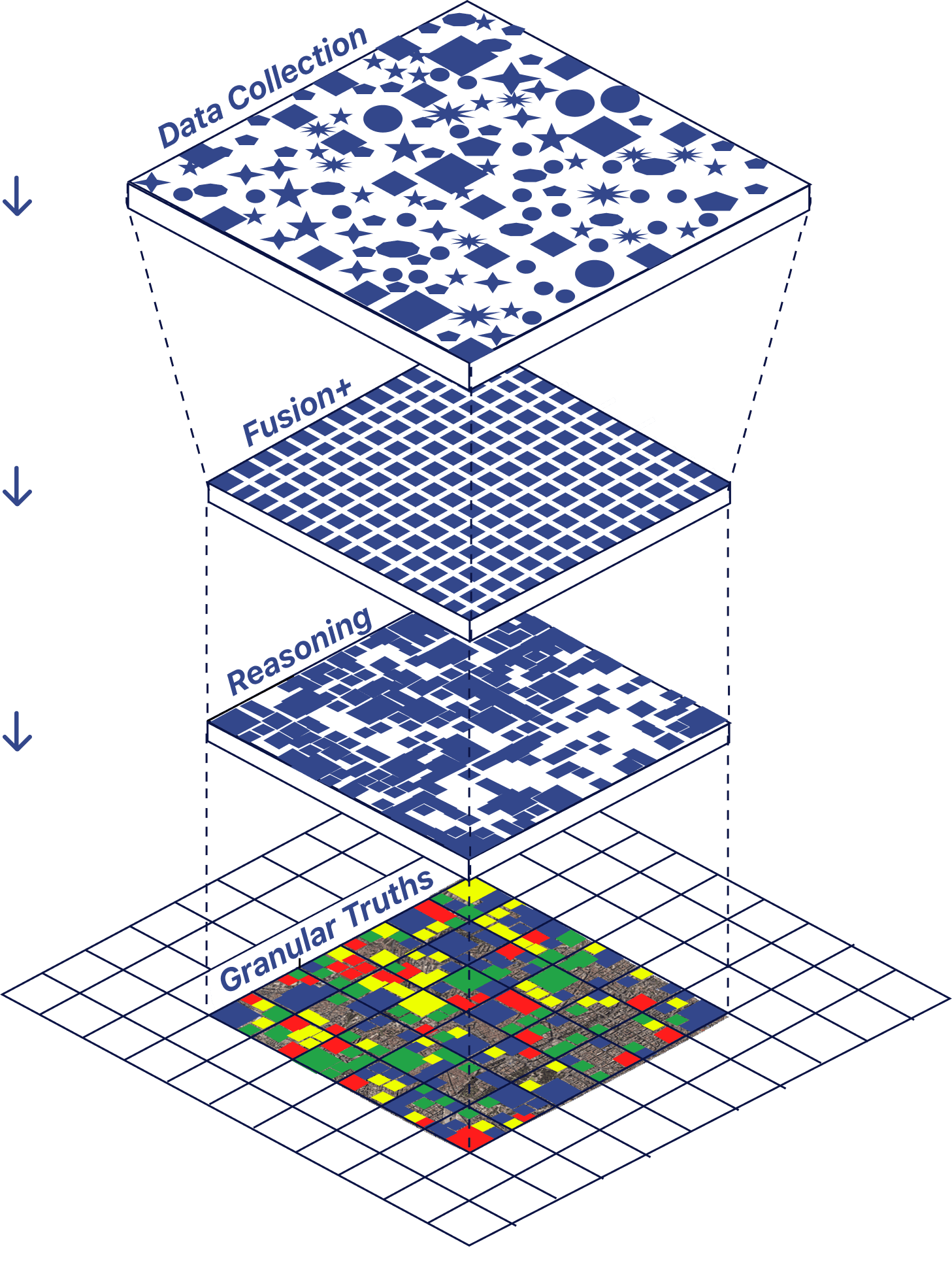
A system comprised of 3 parts: Data Collection, Fusion, and Core Reasoning. Within each are several novel approaches formulated through our applied research, including Data Enzymes and Earth Recipes.
Core Reasoning includes our concept of Earth Recipes: expert-agents that collaborate using our relational-vector architecture.
Why LLMs Didn't Cut It
In this interactive visualisation, we describe several details of our work so far. Tap for an overview of each layer:


Data Collection
The most extensive data collection in the industry. Versatile methods ranging from drones, car data, human data, public data and more.
Read our blogEarth Recipes: How a World Would Think
Read our latest releases
Explore the innovative research and recent papers from our team.
Earth Recipes: How a World Would Think
Building accurate geospatial core reasoning with our concept of Earth Recipes
What is a Large Geospatial Model?
Definition of a Large Geospatial Model, and how it differs from World Models, LLMs and other foundation models

The Philosophy of a Universal Geospatial Model
Our vision for a universally capable model for spatial and geospatial reasoning