Turning Dormant Data Usable
Our data digestion concept of Data Enzymes to aggregated quality training-data at scale and cheaply



December 21, 2025

If this article interests you, consider reaching out. We’re actively looking for ambitious researchers to join our mission.
Here is a fact that surprises most people: an enormous portion of the most valuable data about our planet already exists, it's just currently unusable. Columbus is developing technology to turn dormant data into valuable working data.
The Pinnacle Data Problem and Data Enzymes
Abundant data sits dormant in incompatible formats. It's spatially relevant but not spatially paired. It's broken, out of date, locked in a PDF, in a hand-drawn map or a malformed CSV, scattered across different platforms and databases. Google Maps doesn't have it; OpenStreetMap doesn't have it; sometimes a user-generated-content video has better, fresher information about a place than any existing mapping platform does. The data is everywhere and it is, functionally, nowhere; because no one can find it, fuse it, and trust it.
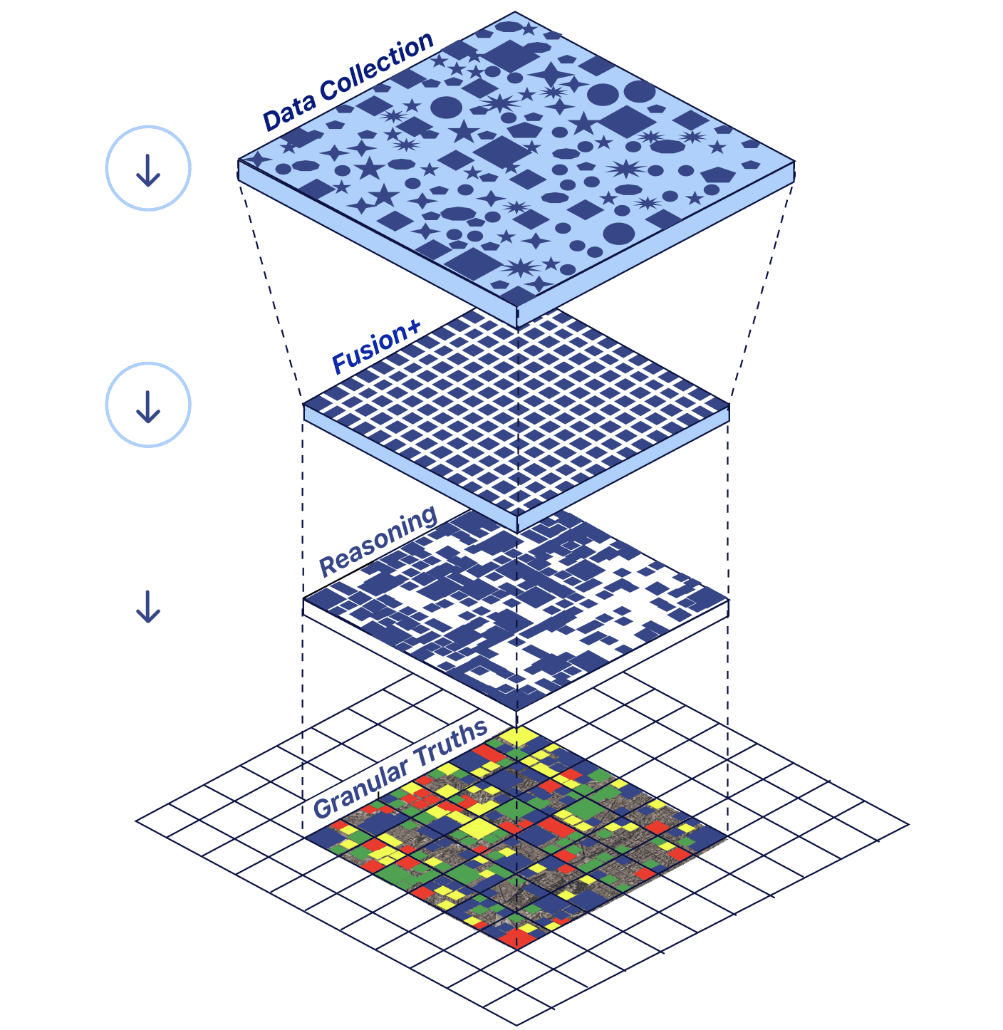
We call this the Pinnacle Data Problem, and solving it is core to what we're building at Columbus. Our approach is a system we think of as Data Enzymes: just as your stomach breaks down food into the nutrients your body can actually use, our data digestion pipeline takes raw, messy, dormant inputs and turns them into clean, structured, well-labeled data the model can learn from.
Concrete examples
1. Take a news article reporting that a 6,000-capacity venue may be built on a parking lot next to a casino in a specific part of Maryland. If we took this news article as a ‘data input’, we’d have no latitude/longitude field, no schema, nothing that a platform like Esri’s ArcGIS can ingest. But it's spatially paired in disguise. It names a place, a proposed structure, a capacity, a likely height inferable from capacity and venue type. Digest a thousand articles like it, and you can assemble a data layer that didn't exist before - e.g., “proposed construction across a region” that a researcher, a planner, or an investor would find useful.
2. An active challenge is digestion when spatial pairing is non-existent: We’re working towards Data Enzymes that can work on data with no explicit location at all. User-generated digital content rarely tags the exact place that produced the opinions in it (whether in the mp4 or public comments), but the person who produced it is reflecting on life in the area they exist in.
Our direction revolves around using image-recognition (VLMs) and clever extrapolation to predict the spatial pairing, inferring the likely area a video belongs to and pairing it, turning unlocatable information into a located data point; while respecting privacy laws, and platform policies by implementing thorough and vetted guardrails to ensure we extract only anonymized POI data. Done at scale, across articles, videos, surveys, sensor feeds, and many more data sources, this will further help build a central, spatially-paired repository for Earth.
Data Enzymes are a critical tool to solving the Pinnacle Data Problem because:
- It increases data volume. We’re not limited to data that arrives pre-formatted and can start feeding our foundation models using a full range of sources.
- It decreases data cost. Digesting existing dormant data is much cheaper than performing new surveys (to fill an information gap that may have already been filled).
- It increases speed. Collection that used to take field teams and months can happen continuously.
On Data Enzymes
Two active commitments keep the enzyme accurate:
Ground truth;
We care about whether each data point is actually true at a specific point in space and time. A fact about a street in 2012 is useful information if properly timestamped, in an ‘attribute timeline’ (a trend in data).
Filtering and validation;
After digestion, data still has to be cleaned, scored for confidence, and cross-validated against other sources before the model is allowed to trust it (i.e. internal truth audits). Freshness and source-trust matter to us at Columbus. A government health department's survey earns more weight than an unverified internet scrape. To be transparent, the scoring layer is some of the most important research we’re pursuing, and it's still in development.
It’s a difficult but even more exciting open problem. If unsolved problems like this interest you, join us and be on the first team to solve the hardest open problems in the field.
At Columbus, we’re data hunters, and data archeologists. Some of the most valuable work in geospatial foundation models will be uncovering data that already existed and bringing it back to life. Columbus wants to create a new class of explorers whose job is to find useful data that no one is using.
If you’re ready for a new frontier, join our crew.