What is a Large Geospatial Model?
Definition of a Large Geospatial Model, and how it differs from World Models, LLMs and other foundation models



June 24, 2026
Columbus is an applied research company. We're looking for researchers who want to help define the next chapter in foundation models. Join us.
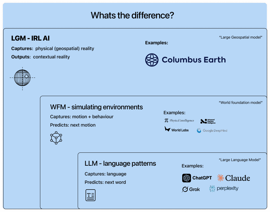
If a Large Language Model (LLM) is for the digital world, a Large Geospatial Model (LGM) is for the real world.
Columbus’ primary research objective is to create a general intelligence for the physical world. But before we delve deeper into our model, let us define what is meant by a "large geospatial model" as the phrase is used to define several different things.
A Large Geospatial Model, or LGM, in its prime form, can be described in multiple ways:
- An AI that has an intuition of geographic space and anthropology within it.
- An AI that understands the semantics of a space.
Defining a Large Geospatial Model
We define the Large Geospatial Model (LGM) as a foundation model trained on the physical world, which may include but not limited to:
- spatial coordinates,
- real-world materials,
- terrain,
- topography,
- the built environment,
- temporal meteorology,
- the living environment, and
- the human activity layered on top of all of it.
Our model can be thought of as an intuitive AI with generalist geography and anthropological intelligence. Though an LLM is quite distinct from an LGM, we’ll use the LLM as a reference point for understanding. Where a language model learns the patterns and relationships in text, an LGM learns the patterns and relationships in geographical spaces. This encompasses not just what is at a place, but how the things at that place relate to one another, and transform over time. An LGM models the state and structure of geographic spaces, learning latent representations of places and their dynamics, whereas an LLM models the statistical structure of language by predicting the next token in a text sequence.
Link to why modern LLMs fell short.
What are the different types of physical AI?
There are different types of models within the spectrum of physical AI:
Columbus Large Geospatial Model:
An LGM is a model that understands the semantic structure of the world itself. By integrating multimodal, multispectral, temporal, and contextual information, it develops latent representations of places that capture what is there, how its elements relate, and how those relationships evolve through time. It functions as an AI with geographic and anthropological intuition, possessing an intuitive understanding of the state, structure, and meaning of environments, ecosystems, and human activity across space and time.
World Foundation Models:
A sibling of the LGM, WFMs are an exciting new frontier. Excellent in capturing motion and physics behavior, they’re made for use in simulating spaces and how physics affects motion for applications such as embodied robotics AI, video games, and AR. WFM is fundamentally about simulating how a space behaves and moves, and an LGM is fundamentally about the grounded geographic and anthropological intelligence at a real, actual place.
Earth-observation and Geospatial Foundation Models:
The open-source Clay model is a good public example. It takes satellite imagery plus location and time and produces embeddings of the Earth's surface. Clay is a Vision Transformer trained by self-supervised learning across multiple satellite sensors. These models perform well within their domain, but that domain has a hard boundary: they see the world through the spectral bands a satellite sees. The human, street-level semantics were never part of the training objective, so they aren't in the embeddings. Versatility is a separate, documented concern: EarthShift (Doerksen & Kerner, 2026), the first public robustness benchmark for geospatial foundation models, reports significant performance degradation when these models face out-of-distribution shifts, with no single model dominating across shift types.
Geo-tuned Large Language Models:
A language model with some spatial fine-tuning. Because its base architecture is designed to predict text, it tokenizes coordinates and spatial data as sequential words. To a Geo-tuned LLM, "40.41° N" is a sequence of characters, not a physical node. However, it is not native to space and is limited in its ability to calculate geometric constraints, continuous topographies, or structural routing.
3D Scene models / Spatial Models:
3D Scene and Spatial models focus on reconstructing and understanding the geometry, physics and appearance of physical places. Niantic Spatial is a leading public example that functions by creating highly detailed 3D representations of real places using billions of images and scans. This impressive work is primarily useful for embodied robotics AI and AR. While they've also referred to their system as an LGM, their model specifically focuses on the spatial side, while Columbus focuses on the geographical and anthropological intelligence side. Niantic Spatial’s and other spatial models are particularly useful for robotic reasoning, to ask for instance: where am I, how am I oriented, what does this structure look like.
The frontier we’re building towards
- truly multi-modal,
- multi-spectral,
- temporal,
- contextual,
- and semantic
Columbus aims to build a big-data foundation model that fuses and reasons across vast and versatile data sources. Rather than treating each modality in isolation, it fuses data sets and reasons across them, for example; satellite data with ground data, public records with private surveys, articles with user-generated digital imagery. The goal is to move beyond just asking "what does this pixel look like," toward answering "what is this place, to whom, and why."
The future we’re building for: Universal Geospatial Model
A Universal Geospatial Model (UGM) is a term we coin for the endpoint: a UGM would be the AGI for the physical world.
A UGM, in application, unifies the geographic and anthropological intelligence of a Large Geospatial Model, with the Spatial intelligence of 3D scene and spatial models. The UGM is a singular AI model that can apply hyper-detailed intelligence and general intuition – from macro-scale Earth reasoning tasks, to detailed, chemical and physics-based topics. It is a model with universal understanding of intimate spaces and planet-scale questions. It could be "dropped" into a place it has never seen – such as a desert in Australia, a stretch of the Chinese mainland, or a square of Amazon rainforest – and could reliably and logically reason about the space the way a hyper-intelligent expert human can, applying intuition through patterns it already understands rather than by having memorized that exact location.
A UGM, in its fully realized form, should be:
- A reasoning engine that replaces static deterministic logic with dynamic spatial inference.
- A semantic AI that can structurally understand and simulate an unseen environment.
- A model that builds an internal representation of a new environment grounded enough to reason over. Reliable in edge cases that break traditional GIS tools.
Read more about how we define a UGM here.
These are difficult problems that are even more exciting to solve. At Columbus, we treat “impossible” as a challenge.
We're a research company. We're looking for researchers who want to define the next chapter in foundation models. Join us.