The Large Geospatial Model: Our Timeline
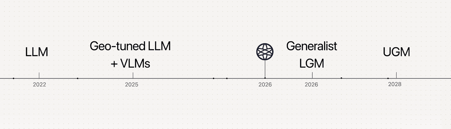
A taxonomy of different types of Physical AI, where we are, and our aimed release dates.



December 18, 2025

Columbus is an applied research company. We're looking for researchers who want to help define the next chapter in foundation models. Join us.
A taxonomy of the current evolution in approaches to the Geospatial AI industry and where the Columbus LGM ‘Magellan’ sits in it:
Category 1: The Large Language Model (LLM).
Transformer-based and attention-driven, trained to predict the next token over tokenized text. Built for language, not coordinates.
Category 2: The Geo-tuned Large Language Model.
A language model with some spatial fine-tuning. Because its base architecture is designed to predict text, it tokenizes coordinates and spatial data as sequential words. To a Geo-tuned LLM, "40.41° N" is a sequence of characters, not a physical node. However, it is not native to space and is limited in its ability to calculate geometric constraints, continuous topographies, or structural routing.
Category 3: Vision, Earth-observation (EO) and Geospatial Foundation Models.
Models such as Clay Embeddings use multi-spectral satellite imagery together with spatial and temporal context to produce vector embeddings that encode meaningful characteristics of the planet’s surface. Trained on relatively large datasets, they perform well within their specific domains. Also, limitations include lossy compression of semantics not relevant to their pretraining objective, and importantly they don't focus on versatile street-level semantic reasoning.
Category 4: The generalist Large Geospatial Model.
A foundation model that is multi-modal, multi-spectral, temporal, contextual, and semantic - fusing data from satellite with ground, public with proprietary, imagery with text. Big-data pre-trained, then fine-tuned for each Earth topic (geology, ecology, the built environment, and so on). This is what a proper "LGM" should mean, and it's what Columbus is currently developing.
Category 5: The Universal Geospatial Model.
A UGM, would be the AGI for the physical world. In application, it unifies the geographic and anthropological intelligence of a Large Geospatial Model with the Spatial intelligence of 3D Scene and Spatial models. A singular AI model that can apply hyper-detailed intelligence and general intuition from macro-scale Earth reasoning tasks to detailed, chemistry- and physics-based topics. The UGM has universal understanding of intimate spaces and of planet-scale questions.
Where is Columbus today?
Currently, we have the foundational architectural concepts and working proof of concepts for category 4: a geo-context model built on critical pillars, such as a data-collection engine (using data enzymes), an aggregated geospatial database, a Smart Layers demo; and a Politecnica University accredited test of a geo-context model applied for fire prediction. The full LGM architecture is still in research and development. We aim to release a complete model within 2027.
Any company claiming to have already solved the physical world is overstating it. We believe in transparency and building in public. That means showing you how far we've gotten, and inviting you to join us on the journey to this exciting and powerful technology. Timelines may shift, but with the right team we’re aggressively pursuing the development of the strongest Geospatial Model in the world to create a paradigm shift in physical-world problem-solving. Real change to real people.
Join us on this mission.